W7ZOI Field Day for 2013
(posted 24June13, Wes Hayward)
The ARRL Field Day is the premier annual amateur radio operating
event for many of us. Occurring on the fourth weekend of June each
year, it is the time
when radio amateurs from the US and Canada go into the field,
often camping,
taking their radio gear with them. Essentially an
excuse to go
out into the wild with portable radio gear to just have a lot of
fun, Field
Day is also an exercise in emergency preparedness.
Most of the
amateur radio community operates from locations that are next to
the road,
often from the comforts of lawn chairs with picnic tables, usually
with large
gasoline powered generators chugging away in the
background. There is a small but growing
faction that integrates FD with a walk into the
hills.
I remember going to the FD site for my old local club when I was
in high school in the late 1950s. The guys in our club
were out for blood with a devoted contest mind set, so the kids
never got a chance to operate. In the early
1960s, when I was beginning to build and experiment with solid
state gear, I started going on FD with battery powered
rigs. Some
of those outings were with friends where we operated next to a
road. The more interesting and fun trips have always
been from the trail.
This year I really wanted to get out for a backpacking
operation. I'm still able to do this and want to take
advantage of it while I still can.
I was lucky to find a willing partner for the trek in John
McCormick, K7CVU.
John, another ex Tektronix guy, has extensive mountaineering
experience in
the American West including Alaska, plus some climbing in
Europe.
Our goal was to pick a site that had a scenic view, was a
reasonable radio
location, and was accessible by trail, perhaps with some modest
cross country
travel. After checking with other local folks who do
this sort
of FD, we found that Ghost Ridge wasn't to be occupied, so we
headed there.
I've been there often and it's a favorite location for day trips
in all seasons.
John had been there on skis in winter.
Ghost Ridge is a name applied by local Nordic ski enthusiasts to
an area south of historic Barlow Pass, an early route across the
Cascade Mountains connecting Oregon's Willamette Valley with the
rest of the Oregon Trail. The Ghost name makes
reference to pioneer graves in the area, attesting to the rigors
of the journey a century and a half ago. Barlow Pass
is accessed from Oregon Highway 35. From a trailhead at the
pass, one hikes south on the Pacific Crest Trail
(PCT.) After just over a mile, the route leaves the
trail to follow the ridge line to the summit of Ghost Ridge at
Peak 4925.
My normal comment, when writing a report of this sort, might be
that the trail hike was casual and uneventful. This
was not the case this year. The trail hike
provided an extremely enjoyable, unique experience that I’ll long
remember. I’ll return to
this later.
Our route is shown in the map below. The Barlow road,
now little more than a jeep path, is presently
closed. The PCT is call the Skyline Trail
on this older map, although that name is no longer used.
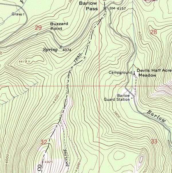
We left the trail at the point where the Skyline Trail peaks and
descends slightly. We now found ourselves in timber
with sparse brush. Following the obvious ridge
line takes one to the summit. There are a couple
of points along the way that provide a good view of Mt. Hood, or
of a local boulder field.
We were frustrated at what we did not find along the
way. There was no snow. I had been
watching Mt. Hood for the last month
from the local hill that I visit on local walks, and had been
impressed by
what looked to be a good snow pack. Checking with
others revealed that the snow pack this year was lower than
normal, but was still heavy at higher
elevations. I made the unfortunate error of
assuming that there would be snow on Ghost
Ridge. But alas, we found the ground to be free
of snow, showing no more than minor dampness from recent
rains. We were depending on the snow for the water for
our camping. We studied north facing, shaded areas
that might have harbored a last remaining snow patch, but found
none. The heavy rains in Oregon last May
evidently removed the intermediate elevation snowpack.
John and I planned on camping in the trees just east of the Ghost
Ridge
summit. The lack of water compromised these
plans.
We only had a total of four liters of water for the two
days.
There were streams and lakes in the area, but it would have taken
several
hours of hiking to go there to fetch additional water.
Our final
solution was to eliminate the camping part of our
plan.
Instead we would put up the antenna, operate for a couple of
hours, cook
an early dinner, hike out to the car, and drive home in the
evening.
Field Day is often a compromise of one sort or another.
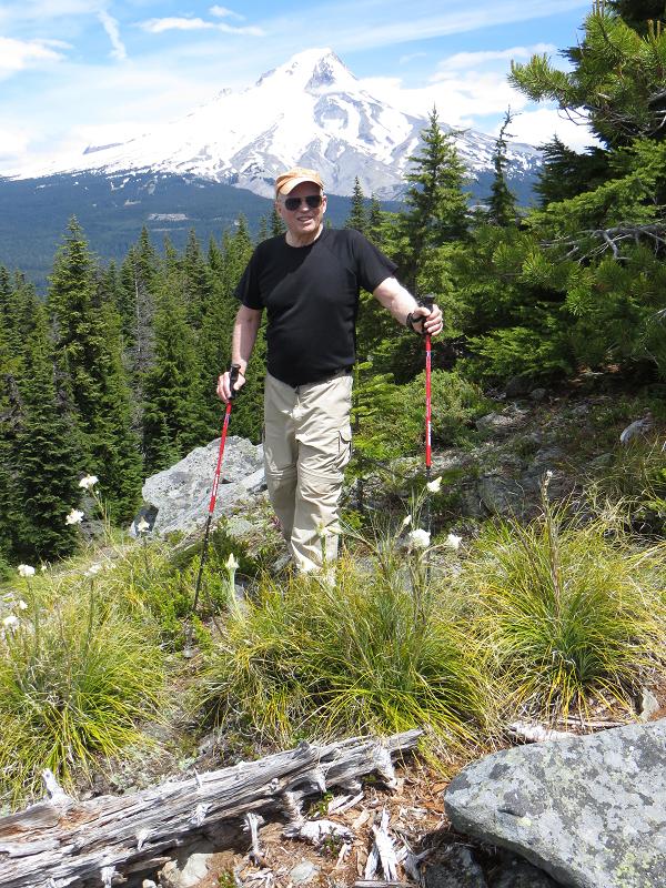
Shortly after arriving, we walked to the actual summit of the
ridge, perhaps 50 feet in elevation above the meadow
area. The photo below shows John with Mt. Hood
in the background. Mt. Jefferson could also be seen,
about 40 miles to the south.
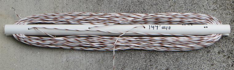
Antennas in the Trees
Our antenna this year was a full wave loop, fed at the bottom
center. We took only an 8 foot piece of RG-58 coax
cable. 144 feet of #18 plastic insulated wire served
as the loop, transported on a piece of PVC.
Slots were cut in the 21 inch pipe to store the wire.
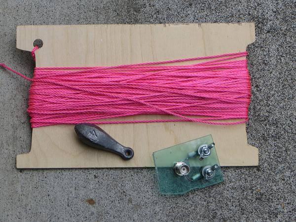
The loop was hoisted into a tree with a piece of brightly colored
Nylon
cord. The cord is wound on a piece of very
thin plywood
for transport, as shown below.
Also shown with the bright cord is a 4 oz lead
fishing weight (left over from the days when we used lead for such
things) plus a center insulator with coax connector to be used
with the closed loop antenna. The cord with the
plywood piece weighs 4.3 oz, which could easily be halved with a
rebuild.
Getting the antenna in the air begins with a tree
selection. Look for a tree with some open
branches that extend past the smaller ones near the tree
trunk. Try to avoid branches covered with
moss. Look for a fairly clear downward path from
the branch to the ground. After tying the weight to
the line, a large length of line is uncoiled onto the ground, well
away from the tree. The goal is to throw the
weight into the tree, over the selected branch, but to allow the
weight to keep going so it pulls the cord for some
distance. The branch selected this year was up by
about 40 feet. We probably had 60 feet of line
on the ground before the weight was thrown. I usually
grip the line about 18 inches from the weight and throw
underhand. John managed to get a great
photo of one of my throws, shown below.
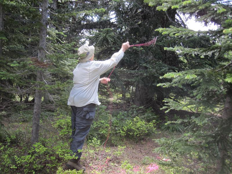 (K7CVU photo.)
The weight went over the branch, but then got stopped by another
branch. It did not stop and tangle because it
had been thrown without tension on the
line on the ground. Use of a heavy weight
helps the
process, pulling the line along as it falls. A
tempered tug or two on the line when it stops may help the
process, but don't get aggressive,
for this can cause the weight to circle a branch and
tangle. Once
this happens, there is no recourse short of climbing the tree or
cutting the
line. A lighter weight will work well with lighter
line, but
it then gets hard to see. A 1 oz weight works
well with
6 pound test mono film fishing line, but a reel is then required
to hold
the line. Bright paint on the weight is often useful.
Once we had the line in the tree, it was used to place the
insulated wire. No extra rope was
required. If we had been putting up a dipole, inverted
Vee, or an end fed wire, we might have attached a heavier rope to
the cord and used the cord to pull the rope into the
tree. The rope would then have been used to lift the
antenna.
Once we got the wire loop up in the tree, the ends were brought
together and attached to the center insulator shown in an earlier
photo. The loop was then tied out with lengths of
cord. This
loop antenna can be lifted into a tree without a heavier
rope. When we erect dipoles, we usually use 1/8 inch
diameter parachute cord to actually support the
antenna. An actual horizontal dipole is a very
rare antenna for me in the mountains. Instead,
an inverted Vee is used with one rope to support the antenna as
well as the feedline. The ends are then pulled out
with additional cord.
One vital rule applies to any of these
variations: Experiment with the variations at
home, if possible. As always, problems are often
avoided with experimental methods.
We got the loop up and installed after two or three
tries. (It never works right with the first
throw. Never!) The station was set
up, with an 8 ft piece of coax
attached directly to the loop. This was then attached
to a small
transmatch that uses screw driver adjusted mica compression
trimmers.
I've used this circuit (with its built-in bridge) for perhaps 20
trips to
the mountains; I keep coming back to it, for its the lightest
antenna tuner
I own.
More information was presented on how we get a wire into the trees
than
might normally be required. The reason is to
offer some
encouragement to a good friend who also went out for FD this
year.
He complained upon his return that “the tree ate my antenna.”
Our operating position is shown below. John is tuning
the band.
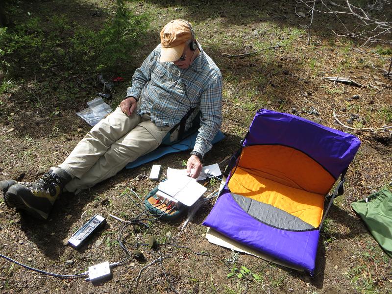
The “chair,” is a cloth and fiberglass structure that uses a
partially inflated air mattress as a pad. I
didn't find it all that comfortable. The power source,
a 2.3 AH, 12 volt sealed lead acid battery, is on the ground near
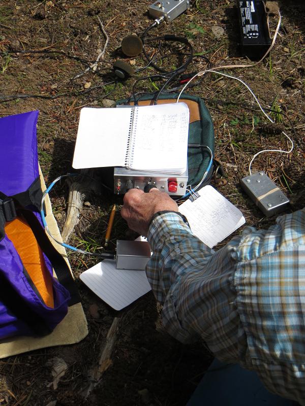
John's boot. A detailed shot of the station is
shown in the next photo. The transceiver is
built in a 2 x 5 x
7 inch box, which has a log book sitting on it.
The transceiver has two headphone outputs. A hand key
is to the right of the transceiver
while the paddle for the built in keyer is under John's arm in the
photo.
Propagation conditions seemed poor during this
contest. We operated the 40 meter CW band and
made only two dozen contacts. This seems to be about
the norm for our 1 W transceiver with a short afternoon operating
stint. I'm sure that this would have expanded
significantly if we had added Sunday morning
operations. Higher power is also a
possibility. There is always next year…
After taking the antenna down, we cooked a freeze dried
dinner. John had brought a new cooking tool, an MSR
Reactor Stove System. I was extremely
impressed. I've never seen a stove that was this
quick.
Hiking Companions
Earlier I alluded to an unusual experience on the approach
hike. It started at the trailhead parking
lot. John and I were donning our boots and
getting packs ready when a couple drove in and parked just down
the lot from us. They walked by to begin the
trail.
I said hello and started a conversation. Folks are
openly friendly
in the mountains, it seems. Something was said about
the Mazamas
and a name was mentioned. John recognized it, and it
soon became
clear that they had mutual acquaintances within the local hiking
and climbing
community. The gal then introduced themselves as Don
and Roberta
Lowe. I nearly fell out of my boots, for the
Lowes are
legendary for their books on the trails of Oregon, and later of
California
and Colorado. I have four of their Oregon books in my
library,
the first being “100 Oregon Hiking Trails,”
(Touchstone
Press, 1969.) The photo below shows
Roberta and Don
with me.
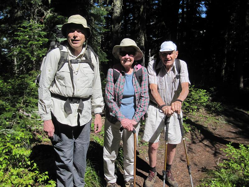 left-to-right: Wes, Roberta, Don. (K7CVU photo.)
It was a tremendous pleasure to hike with them for a while.
The four of us hiked together until reaching the point where John
and I left the PCT to go up the hill.
Many thanks to John for the use of his photos.